Last Thursday, Tiffany and I drove down to Zion and got all our stuff, backcountry permits, gear, campsite, all of that. Hiking the Narrows requires jumping over a few hurdles. Only a certain number of people are given permits each day, and only 12 parties are allowed to actually camp overnight within the Narrows, so we were lucky to have reserved a spot a month in advance. There are three ways to hike the Narrows, you can dayhike the entire thing from top to bottom and get out before it's dark, you can do the overnight trip which allows you to really take it easy and enjoy it all more slowly, or you can do what most of the tourists do and hike in from the bottom up as far as you like (for most of them, that's maaaaybe 3 miles up the Narrows) before turning back. Bottom up hikers do not require a permit, but they're limited in exactly how far they're allowed to hike, though how anyone enforces that, I have no idea. Didn't see a ranger there at any time on our trip.
Tiffy and I woke up on Friday at 530, packed up camp, drove up to the visitor's center, and caught our trailhead shuttle just in time at 630. It was eerie and wonderful to be driving up out of Zion in near-total darkness, save for the bluish-black outlines of jagged mountains in the sky. Our bus driver told us that the indians thought that Zion was haunted, so they never, ever went into it but instead lived in an adjacent canyon system. I can see why.. .the rocks there look so strange, jutting out in all different directions, made of so many colors, with waterpockets and rock fins. An hour and a half after climbing into the shuttle, we arrived at the trailhead, located on Chamberlain's Ranch. It was FREEZING COLD, must have been in the mid to upper 40s so everyone was jittery. Tiff and I put on all our remaining clothes and still didn't feel very warm. SO glad I remembered to have us bring winter hat and gloves, we would have been in trouble without them.
The first 2 or 3 miles of the trail runs through this guy's ranch, so you're greeted with cow stares the entire way and lots of mooing as you walk along the gravel road. Finally, the mouth of the canyon started opening up and we made our first real river crossings.
We hiked 8 miles the first day, passing through what Tiff and I both felt was the most spectacular scenery of the entire hike. We reaaally took our time. The map said that it would only take us 5 hours to reach our campsite, but somehow it took us 7 hours. Here is a really good description from this website I found:
"The diverse trek through Zion's premier canyon is one of the most touted and breathtaking adventures in America. Extraordinary beauty and unique character describe this amazing gorge. Hanging gardens burst from dramatically colored perpendicular walls while trickling water threads its way through moss covered boulders. Gentle slopes give way to sheer walls funneling streams of water into fluted slides and twisting channels cutting deeper and deeper as the journey continues its path southward. Along the sandy perches of the banks, towering ponderosa send their roots downward, hungry for nutrients and water. The entire trip is wondrous. The Zion Narrows deserves its reputation as one of the best, if not the best, hike in the National Park System."
The park will not issue permits to do this hike if the river is running faster than 120 cfs, or if there is any rain within a 100-mile radius of the park. We were really lucky we went when we did because there were thunderstorms forecast for the very next day after we finished our hike.
I'd say that we crossed the north fork of the Virgin River at least 150 times on that first day. The entire trail is basically walking down a river, crisscrossing from one shallow section to another, with the occasional reprieve of a few sandy beach sections and some grassy forested parts. During the first day, we never encountered any sections more than knee-deep
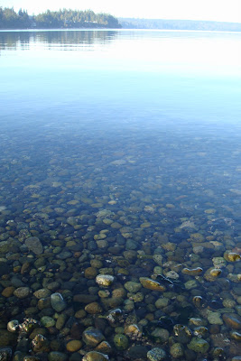
Cool rocks --

The river is our trail --

Beautiful fall colors --

CHECK OUT THIS HUGE ROOT SYSTEM --

I love this picture, with that little patch of blue sky in the corner --

Gorgeous, we walked through here, between the walls --

Tiffany and I both agreed, the entire trek was like walking through a fairyland. We spent a minute here, pawing at the leaves --

Mmm, waterpockets - -

GAAAAAH --

The fall colors were incredible, and it was joyous to walk down the river with so many pretty leaves in pink and green and yellow and orange being whisked briskly downstream underfoot. LOOK HOW CLEAR THAT WATER IS!

Yes, our trail led directly into this little slot canyon --

Haha, here, Tiffany and I were approaching this from on top, wondering what was going on with the water suddenly disappearing over here, until we got to the edge and realized there was a 20-foot WATERFALL in our tiny canyon. The only way to get downstream is a skinny, steep, sandy passage between two rock fins to the left of this photo (not visible) --

Our favorite narrows were found on the first day --

Our campsite for the night is straight ahead, down this canyon between these walls, about 10 minutes beyond this point --

I'm always so impressed by the tenacity of trees --

Our campsite came with this wicked cool rock to lean all of our stuff up against --

With view of the river --

We arrived around 5 pm and had eaten dinner and had our hot chocolate by 6 pm. After hanging everything up to dry, we crashed in our sleeping bags and slept until 730am the next morning, that's how tired we were.
Tiffany was smart and brought an alarm with her and woke us up in time to get moving. We had oatmeal and hot chocolate for breakfast, packed up camp, and headed out by 9am. The second day was very, very difficult. The hike is strenuous, there's no doubt about that, and it's not for everyone. While the gradient is gentle, there are numerous obstacles to work your way around and lots of deep sections where you almost have to swim. Lots of boulder hopping and scrambling and swift-current crossings over little rapids and scouting out how to get to the most shallow side of the river. There were a few areas where we had to crawl over log-jammed debris from previous flash floods... There is no way anyone could survive a flash flood in there. It was in the back of my mind the entire time. After 3 miles or so we hit a lovely place called Big Springs, where three waterfalls flow out of the base of a 200-ft rock wall --


After this point, the longest section of narrows begins, requires 2.5 hours of hiking/swimming/fording, and there is no safe high-ground anywhere along the stretch, should a flash flood occur. I was very nervous about it. Okay, really scared, actually. But we plunged ahead, dealing with every single obstacle we came across (there were quite a few). There was one point where the sheer cliff walls were ten feet apart, with nothing between them but the river, chest-deep for 100 yards, that we had to gingerly hop/float down (with our big packs on). That part was really cool! Seriously, kinda fun. Later on, we hit another really deep section, up to our necks almost. After that point, we started to see the dayhikers hiking up from the bottom and then the place got really crowded with loads of tourists hiking up with no poles, wearing ridiculous things like flip flops.
Tiffany in one of the more shallow sections on the second day --

My one photo of the most photographed section of the Narrows, this section is called Wall Street for obvious reasons. Just incredible --

So we made it out of there alive, 16 amazing, awe-inspiring, tough miles in 2 days, and now I can cross that one off my list. Afterwards we caught the shuttle back to the visitor's center, picked up my car, returned our gear, and immediately went to the first restaurant we saw, which was the Spotted Dog Cafe. I had mesquite chicken with vegetables and sweet potato fries and a glass of riesling, and Tiffany had pasta. Also bought a plate of flat bread and hummus. DELICIOUS food, fantastic service.
I am so grateful to Tffany for coming along with me and so proud of her for facing all of those obstacles and for overcoming her fear of heights and swift-current river crossings in order to get the job done. We sure had an adventure!
 During the month of January, hundreds of bald eagles can be seen here feeding on salmon in the Skagit River. We wanted to get in on that action but arrived a little too late, around 10:30 am or so, by which time the eagles had fed and fled. We only saw 2 lone bald eagles regally perched in trees across the river, which was incredibly cool, nontheless. They have wingspans of up to 6 feet!
  We also saw this blue heron stalking fish in the water. Cars were rushing by barely 5 feet away, but she was so focused on carefully and sloooowly creeping up to the water, she didn't even blink. It was kind of freaky to watch, actually:
 After a little exploration, we found this old structure, probably once part of a rock quarry operation, now with shotgun shells littering the ground all around it and gang tags all over it:
 I love seeing abandoned vestiges of another era:
 Tenacious little plants growing on the rust:
  Here is the REAL Baker Lake that we later found --


 That looks perfectly green looking at it towards the sun:


